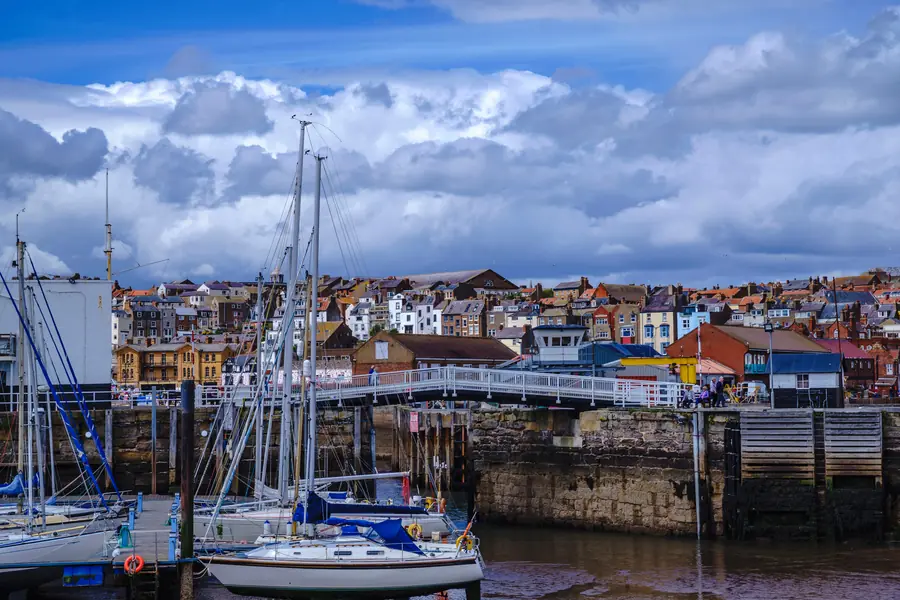
Scarborough Harbour sits at the north end of South Bay, in the lee of the castle headland, and it is still a working port. Fish come in at the West Pier. Leisure boats dry out in the outer harbour at low water. A drawbridge on Vincent Pier splits the two. Gulls run the rest.
It is not the castle. The castle is on the rock above. The harbour is the reason the medieval town grew on this side of the headland rather than the other, and it is the right first hour of a South Bay day if you want boats, chips and a wall to sit on before you walk the sand.
North Yorkshire Council is the harbour authority. Notices, berthing and the tide board live on the council harbour pages. This is the visitor version: where to stand, when the water leaves, and how not to treat a working quay as a playground.
The harbour is older than the resort. There has been a port here in some form since the thirteenth century. In the nineteenth it was a shipbuilding harbour and a herring port; through the late twentieth it took a commercial North Sea fleet. Cargo has gone. The council’s harbour strategy still counts a working fishing fleet — smaller boats, most of them under ten metres, mostly shellfish — with visiting prawn and scallop vessels using the same quay.
Vincent Pier divides the water into two.
The inner harbour, against the West Pier and North Wharf, is the commercial side: the fish quay, landing davits, the boats that still earn a living. The outer harbour, between Vincent Pier and the East Pier, is leisure — pontoons, chain moorings, private craft — and it dries at low water. That last fact is the one that surprises people who came for a picture of floating boats and found mud.
The entrance faces south, which is why this bay held a harbour when North Bay did not. East Pier, West Pier and the lighthouse pier keep the North Sea off it, most of the time.
West Pier is the public face of the working harbour. The fish quay runs along the inner side, about 180 metres, reserved for vessels landing catch. Ice, diesel, water and the watchkeeper are all here. You will see boxes, pots, nets and people who are not on holiday.
Stand on the pier, not on the quay edge, and do not get in the way of a landing. The RNLI station sits on the seaward side. The lifeboat is part of the same working strip, not an exhibit.
There is a council car park on the pier itself — 109 spaces, the closest park to the boats, full early on warm days. Details in the parking guide. The buildings on the pier include the sort of shed-and-bistro mix a working harbour grows when visitors arrive: seafood at the source, and gulls who have learned the timetable.
Watching a catch come in is free and better than most of the paid attractions on Foreshore Road. It is also not a performance. Keep children back from the edge, keep dogs on a lead, and do not treat stacked pots as climbing.
Vincent Pier is the spine. It carries the lighthouse at the seaward end and a drawbridge that opens to let craft through between inner and outer harbours. The bridge is the thing in the photographs — and the thing to stand clear of when it is working.
The inner face of Vincent Pier takes larger commercial and passenger boats. The outer face dries. A wooden jetty runs off it into the outer harbour. Below the lighthouse, in season, local port services keep a presence; the lighthouse itself is not a public attraction.
In winter a boom has been used across one entrance, forcing traffic through the drawbridge gap. That is a mariner’s problem. For a walker it means the harbour looks different in January: fewer visiting boats, more of the structure visible, the same gulls.
Do not walk under the bridge when boats are using it. The council’s own navigation notes treat that exit as a hazard at peak times. Use the East Pier entrance in your photographs if you want the outer harbour from the wall; use Vincent Pier if you want the drawbridge and the lighthouse.
This is a drying harbour. The outer berths, Lancaster Flats and stretches of the inner side all take the bottom at low water. Depth at the pier heads changes with springs, neaps and the wind — a north wind lifts the water, a south wind drops it. The harbour office works Channel 12 as Scarborough LPS if you are arriving in a boat. If you are arriving on foot, you only need to know that low water empties the picture.
High water is when the outer harbour looks like a harbour. Low water is when you see the legs of the pontoons, the mud, and how much of this port is a tidal pond with walls. Both are worth seeing. Neither is a surprise if you have looked at a tide table.
The same tides shrink South Bay beach. A high-water afternoon on a summer Saturday leaves a strip of sand and a lot of people. A low-water morning gives you the beach at its widest and the harbour at its emptiest. Plan the two together: harbour at half tide on the way in, beach as the water drops, or the other way round.
Short speedboat and sea trips run from the West Pier through the summer, along with fishing trips and the usual small-boat traffic. They are seasonal, weather-dependent, and they cancel when the North Sea is in a mood. Operators change. Walk the pier and read the boards rather than booking a specific hour from a page written in March.
Jet skis are not permitted in the harbour limits, including South Bay. That is a harbour rule, not a suggestion.
The passenger boats that use Vincent Pier in season are the other way onto the water: longer trips, more shelter, still subject to the sea. If the wall is already wet from spray, the trip you wanted is probably not running.
Winter is for watching, not boarding. The fleet still lands. The pleasure boats do not.
The harbour wall is the correct place to eat fish and chips in Scarborough, and the herring gulls know it. They are large, they are practised, and they will take food from a hand, a tray or a child’s grip without ceremony. Sit with your back to a wall, eat quickly, and do not feed them. Feeding is how the next visitor loses a batter.
Luna Park occupies the East Pier end of this same strip: a funfair at the harbour mouth, lights in the evening, the traditional seaside at full volume. It is the other half of the South Bay bargain. The harbour is working boats; ten metres away is a waltzers. That collision is the point of this end of town, not a problem with it.
Foreshore Road runs south from here — arcades, more chips, the beach, and eventually the Spa. You can walk it in twenty minutes. You can also stay on the quay for an hour and let the road wait.
The harbour is the north end of the original beach, not a separate destination with its own day.
A simple circuit: park at West Pier or South Bay Underground, walk the inner quay, cross toward Vincent Pier for the drawbridge and the lighthouse, then drop onto the sand if the tide has left you any. Walk south toward the Spa as far as you want. Come back along Foreshore Road. That is a South Bay morning, and it does not need the castle.
If you do want the headland, climb from the harbour through the old town — Eastborough, Quay Street, Princess Street — past St Mary’s, where Anne Brontë is buried, and up to the castle. It is steep. It is also the historical sequence: harbour first, fortress above, resort later. The castle article covers the top. This page stops at the wall.
Marine Drive starts here and rounds the headland to North Bay at sea level, about twenty-five minutes if the road is open. In a heavy sea it closes. Do not treat the Drive as a harbour overflow car park; it is a sea wall with bays, and it is the first place the weather takes. See the two bays guide for which beach to use once you have left the quay.
A calm high-water morning is the postcard: boats floating, lighthouse, castle on the crag, South Bay curving away. A low-water afternoon is the working picture: mud, keels, pots, the smell.
A big sea is the third version, and it is the one people remember. Watch it from behind the harbour wall, not from the exposed end of the piers. The East and West Piers take water. The RNLI exists because this coast does not always stay outside the walls.
Rain does not close the harbour. It clears Foreshore Road of people who had a beach in mind and leaves the quay to anyone in a coat. The rain guide has the indoor rest of that day.