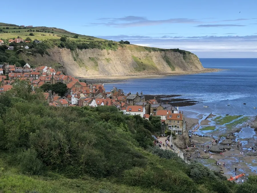
Robin Hood’s Bay is a village built into a fissure between two steep cliffs on the coast north of Scarborough, its sandstone houses stacked under red-tiled roofs. The shape of the place is the reason to go: one street, New Road, falls from the clifftop past the manor house and St Stephen’s Church, through a maze of tiny lanes, crosses the King’s Beck and reaches the sand at a cobbled slipway called Wayfoot.
The straight-line distance is 18.9 km, the furthest of the villages in this guide, so it is a day out rather than an afternoon detour. It lies inside the North York Moors National Park, on the coastal section of the Cleveland Way, and it is the eastern end of Wainwright’s Coast to Coast Walk, which begins at St Bees Head on the Cumbrian coast.
Robin Hood’s Bay and Beach carries 4.8 from 2,025 Google reviews, and what those reviewers warn about, almost without exception, is the gradient.
You leave the car at the top and walk down. Many houses were built between 1650 and 1750, and the alleys and stepped passages between them are narrow enough that the lower village works only on foot. Pubs, cafés and shops line the descent, and so do steps: a visitor in July 2026 advised anyone coming to “Be mindful of steep stone roads with staircases by the road.” The climb back is what people underestimate. Another visitor in July 2026 wrote, “Worth the walk down the steep incline take it steady on the way back up.” Take that seriously if you are pushing a buggy: there is no alternative route up.
A July 2026 review that otherwise praised the pub by the beach reported “Rather a lot of sand flies when sitting outside.” That same positive account was filed as one star, so individual scores here are worth little.
The bay runs between two headlands, Ness Point (North Cheek) to the north and Old Peak (South Cheek) to the south. The cliffs are Upper Lias shale capped by Dogger and False Bedded Sandstones, and the geology matters beyond the village — the Wine Haven Profile nearby is the international reference section for the Pliensbachian stage of the Early Jurassic.
That translates into fossils: the foreshore rocks on the north side of the bay are a well known place to find ammonites, particularly after winter storms. The sand itself is a low-tide feature — “Plenty of sand at low tide,” as a visitor put it in July 2026 — so check what the tide is doing before planning anything along the shore.
South along the coast is Boggle Hole, where the YHA hostel doubles as a walkers’ stop and carries 4.6 from 1,173 Google reviews. A visitor in June 2026 called it “An easy walk round from Robin Hoods Bay”, following the path along the coast top.
The National Trust runs the Old Coastguard Station, 4.5 from 852 Google reviews, and opinion on it splits. A visitor in June 2026 described a “Really nice cafe downstairs with a small museum upstairs detailing the history of the building and Robin Hoods Bay”. A visitor in April 2026 was scathing: “Most boring National trust I’ve visited. More effort and space has gone into the café”. Both are fair: a small exhibition attached to a café, not a day’s worth of museum.
There is also Robin Hood’s Bay Museum, 4.5 from 119 Google reviews, a mosaic sea wall showing 5.0 from four reviews, too few to mean anything, and a playground. That is close to the full list: this is a small village, and the beach and the walking are what a visit is made of.
The name is old and unexplained — attested as “Robyn Hoodis Baye” in 1544, with no reason to think Robin Hood was ever near it. Settlement began inland at Raw and reached the coast by about 1500; Leland saw it in 1536 as “A fischer tounlet of 20 bootes with Dok or Bosom of a mile yn length.” In the 16th century it mattered more as a port than Whitby did, marked with tall houses and an anchor on the North Sea charts Waghenaer published in 1586.
Smuggling followed. Through the late 18th century contraband tea, gin, rum, brandy and tobacco came in from the Netherlands and France, and the village is reputed to hold underground passages linking the houses. In 1773 two excise cutters, the Mermaid and the Eagle, were driven out of the bay by a schooner and two shallops; in 1779 smugglers and excise men fought in the dock over 200 casks of spirits.
Fishing was the legitimate trade, at its height in the mid 19th century, the catch carried inland in panniers over the moorland tracks to Pickering or York. The best-remembered episode is a rescue: when the brig Visiter ran aground in a storm on 18 January 1881, Whitby’s lifeboat was dragged 6 miles (9.7 km) overland by 18 horses, 200 men clearing snowdrifts 7 feet deep and garden walls coming down to get the carriage round the bends. The fishing fell away from the late 19th century, and visitors took its place.
By road the village connects to the A171, the moor road between Scarborough and Whitby. Parking is at the top: Bank Top Car Park, on Robin Hood’s Bay Road, carries 4.3 from 697 Google reviews.
By bus, the X93 Arriva service between Scarborough and Middlesbrough passes through the village hourly, rising to every 30 minutes or every 20 minutes in summer.
There is no railway. The station on the Scarborough and Whitby Railway opened in 1885 and closed in 1965; the nearest now is Whitby. The line survives as the Cinder Track, a traffic-free path of about 21 miles on National Cycle Route 1, running from Scarborough through Cloughton and Hawsker to the village and on to Whitby; you join it behind the Sainsbury’s off Falsgrave Road. It is level, but winds a mile or two inland, so there is less sea than you might expect, and its compacted surface suits hybrids and mountain bikes better than road bikes. Cinder Bike Hire works out of the old station yard on Station Road. On foot, the other car-free approach is the Cleveland Way along the cliffs.
The village and what is around it, at walking scale.
Open any of them in Google Maps for directions and current opening.
Attractions, prices and availability in Scarborough
These come from GetYourGuide's booking widget, which sets their cookies in your browser. Consent to load it and see the attractions and prices.
Background on Robin Hood's Bay draws on its Wikipedia article, text there being available under CC BY-SA 4.0.